
Map and Key Locations of Jamestown, RI
Oct 20, 2016 9:49:10 GMT -5
Charles Murphy and Henry Doberman like this
Post by Claira McAllison on Oct 20, 2016 9:49:10 GMT -5
An over look map of Jamestown. The Purple outline is the area in which the Community has taken control of at the current point in Time. Surrounding the Island is an eight foot rock face cliff, the reason why they don't have a wall or a chain link fence to surround the island from incoming threat such as Walkers. All over the Island, there are Radio Tower's Scattered about so that a Signal can reach all over the Island and even reach out to the main land.

At the Coast line cliff face of the Southern part of the main Island is where you'll find Claira at times of the day, her Property is Outlined in the next image. The house to the left of her property is for her Second in Command (Slot is still open until further Notice) For about Half of the Southern section of the Island is wooded area where a good portion of the homes are. All the home's driveways are attached to the main road that wraps around to head back to the main part of the Island.

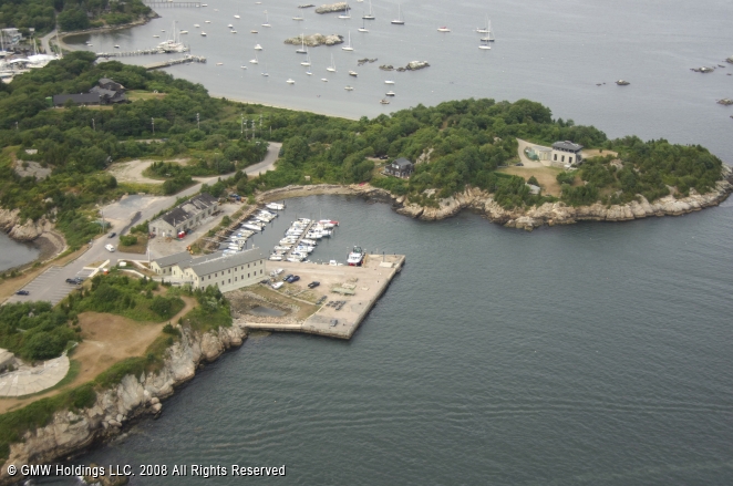
At the Northern Portion of the Island is the port and Trading outposts. The main building at the Pier is where Group Leader/ Traders check in with the Security Guard before Moving on further into the Island or to go either up a floor where there is stands open for trade such as clothing, Canned goods, Blankets, tools, or other Gear such as camping supplies. The black roofed building towards the upper left of the image is where you go to trade for Ammo, weaponry and medical supplies. The building on the upper right of the image is a Lookout post where Sentries inside will radio in of Incoming boats/ Vessels. The house down the road the outpost is for the Guards of this portion of the Island to live in. There is a Motel where guests can stay at for a few nights that is just off the Pier.
At the Center of the Island, it's were a good portion of the jobs could be seen listed on Bulletin boards. It's where the Library for the Meet n Greet happens, Town Hall for the Island to have a meeting about matters that is happening on the island, Some shops and stores, A mall, An Elementary School and Highschool, The Hospital, and the Radio Tower that is used for Communications is also located there. Across the Street from the Library and Town hall is where the Mechanics work at in a complex that has enough room in the parking lot for the Convoy vehicles. Near at the Center of the Town is the Oyster Bar.
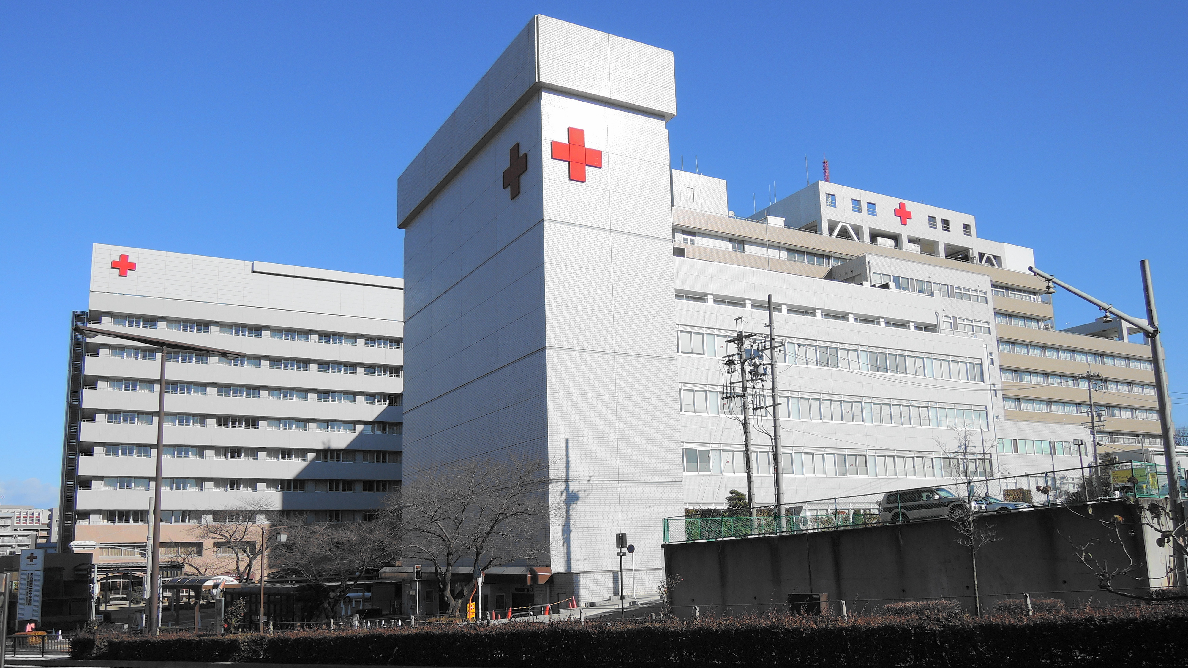
(The Hospital is Currently stocked up on Medical Gear, supplies. 12 Floors, Roof Tops are covered with Solar Panels to provide the needed Power to make the Hospital work at 100%.)
(Town Hall is also a Church.)
(Jamestown Library and Playground out back)
(Shopping Mall)
(Oyster Bar, Has most Alcohol on hand)
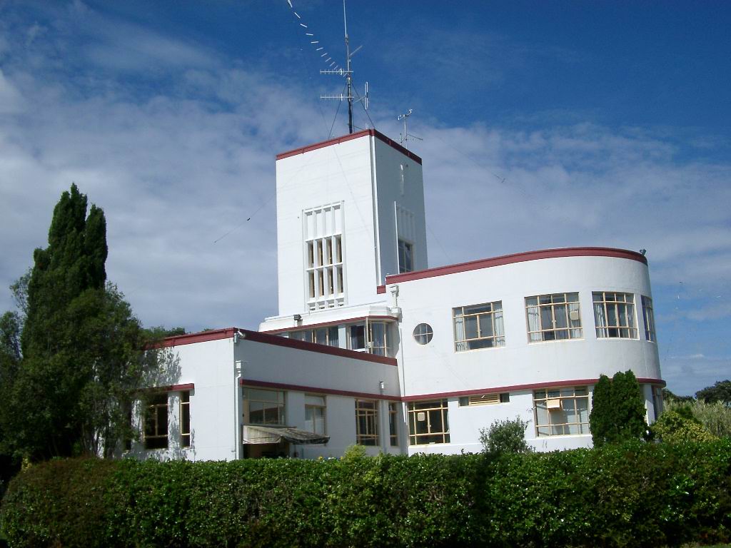
(Radio Station Building and Studios where music is played and Comm's to other parts of the Island is transferred or to the Main land.)

--------------------------------------------------------------------------------------------------------
Southern attached Island, {Conanicut Island}
Towards the South-Western part of Jamestown Island is a smaller Island named Conanicut Island. It is connected one of two ways: Underground tunnel and a Bridge. On the Island is a few key location's to keep in mind when exploring this portion of the island since the homes were deserted and the inhabitants of Jamestown has avoided the homes in case there are walkers inside of them.
Fort Getty Park,
Fort Getty's construction began in 1901 to defend the West Passage of Narragansett Bay as part of the Coast Defenses of Narragansett Bay (renamed Harbor Defenses in 1925). The fort was named for Colonel George W. Getty, who had a distinguished career in the Mexican-American War, American Civil War, and afterward. The fort's three gun batteries were completed by 1905 but for some reason were not accepted until 1910. They were Battery Tousard with three 12-inch M1900 guns (305 mm) on disappearing carriages, Battery House with two 6-inch M1900 guns (152 mm) on pedestal mounts, and Battery Whiting with two 3-inch M1903 guns (76 mm) on pedestal mounts.
Battery Tousard was named for Louis de Tousard, an engineer and artillery officer with much involvement in early American fortifications. Battery House was named for Major General James House, who commanded Fort Wolcott in Newport in 1811. Battery Whiting was named for Levi Whiting, an artillery officer in the War of 1812.
Fort Getty went into caretaker status soon after completion, but was garrisoned in World War I as a sub-post of Fort Greble.
Early in World War II the fort's location was largely superseded by new defenses centered on Fort Church and Fort Greene. In 1942 the 12-inch guns were scrapped, Battery House's 6-inch guns were relocated to Fort Varnum, and Battery Whiting's 3-inch guns were relocated to Fort Burnside. The fort became a prisoner-of-war camp for German prisoners. However, in 1943 a new Anti-Motor Torpedo Boat Battery, AMTB 922 with four 90 mm guns arrived. Two of the guns were on fixed mounts and two were on towed mounts.
In 1948 the fort was disestablished, as were essentially all US coast defenses.
Now a days it is used as a Look out post for the Western part of the River in case of Incoming Boats or those going up the coast on the other banks of Rhode Island. It has four guards at it at all times. The guards there sleep and eat there. When two aren't on duty, the other two are on they're down time. There's a radio system inside of it that is connected to the Radio station in Jamestown's Central portion of the Island so they can say in radio contact.
Near the bottom is what powers this island, USA Nica Windpower Inc. Across this island is Wind Mill turbine's that spin around the clock to power all the buildings of this portion. A few electricians and mechanics are here around the clock to make sure there is no problem with the power flow and with the Turbines.
At the Furthest Tip is the Beavertail Lighthouse Museum.
built in 1856, was and still is the premier lighthouse in Rhode Island, United States, marking the entrance to Narragansett Bay. The 64-foot (20 m) lighthouse lies on the southernmost point of Conanicut Island in the town of Jamestown, Rhode Island in Beavertail State Park, on a site where beacons have stood since the early 18th century. The Whistle House and Garage were destroyed by the New England Hurricane of 1938. The light provides navigation for boats and ships entering Narragansett Bay in the East Passage between Conanicut Island and Newport, Rhode Island on Aquidneck Island. Other lighthouses, such as Castle Hill Lighthouse, Point Judith Light, and Rose Island Light are visible from Beavertail Lighthouse.
Its white light rotates counterclockwise and makes a full rotation in about six or seven seconds. The light is on 24 hours per day with a rotation every 6 seconds, unlike many lighthouses that are near it. It has a loud foghorn that blasts about every 30 seconds during the fog.
It's now Used to Keep an eye on the River and if any vessel's are seen, they would activate the light in the tower and radio the person or People on board the vessel to dock at the North Port On Jamestown Island, then radio up ahead to the Radio Tower and the Trading port to expect incoming visitors. The three people that are stationed here live inside or in a house near by the Lighthouse.
At the Coast line cliff face of the Southern part of the main Island is where you'll find Claira at times of the day, her Property is Outlined in the next image. The house to the left of her property is for her Second in Command (Slot is still open until further Notice) For about Half of the Southern section of the Island is wooded area where a good portion of the homes are. All the home's driveways are attached to the main road that wraps around to head back to the main part of the Island.
At the Northern Portion of the Island is the port and Trading outposts. The main building at the Pier is where Group Leader/ Traders check in with the Security Guard before Moving on further into the Island or to go either up a floor where there is stands open for trade such as clothing, Canned goods, Blankets, tools, or other Gear such as camping supplies. The black roofed building towards the upper left of the image is where you go to trade for Ammo, weaponry and medical supplies. The building on the upper right of the image is a Lookout post where Sentries inside will radio in of Incoming boats/ Vessels. The house down the road the outpost is for the Guards of this portion of the Island to live in. There is a Motel where guests can stay at for a few nights that is just off the Pier.
At the Center of the Island, it's were a good portion of the jobs could be seen listed on Bulletin boards. It's where the Library for the Meet n Greet happens, Town Hall for the Island to have a meeting about matters that is happening on the island, Some shops and stores, A mall, An Elementary School and Highschool, The Hospital, and the Radio Tower that is used for Communications is also located there. Across the Street from the Library and Town hall is where the Mechanics work at in a complex that has enough room in the parking lot for the Convoy vehicles. Near at the Center of the Town is the Oyster Bar.
(The Hospital is Currently stocked up on Medical Gear, supplies. 12 Floors, Roof Tops are covered with Solar Panels to provide the needed Power to make the Hospital work at 100%.)
{SPOILER-Click to Reveal, Hospital}
(Town Hall is also a Church.)
{Spoiler- Click to see Town Hall}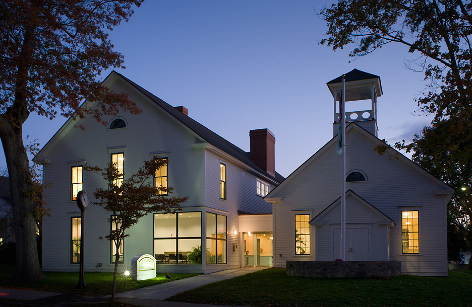
(Jamestown Library and Playground out back)
{Spoiler- Click to see Library and Playground}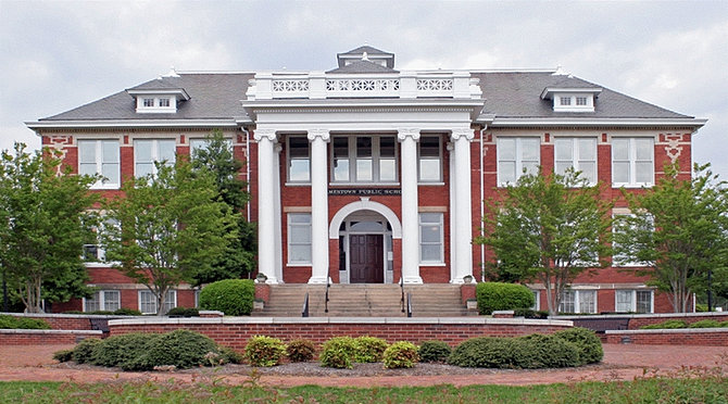

(Shopping Mall)
{Spoiler for Shopping Mall and Food court}

(Oyster Bar, Has most Alcohol on hand)
{Spoiler for the Oyster Bar and inside}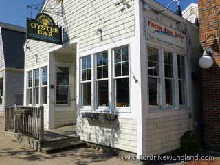

(Radio Station Building and Studios where music is played and Comm's to other parts of the Island is transferred or to the Main land.)
--------------------------------------------------------------------------------------------------------
Southern attached Island, {Conanicut Island}
Towards the South-Western part of Jamestown Island is a smaller Island named Conanicut Island. It is connected one of two ways: Underground tunnel and a Bridge. On the Island is a few key location's to keep in mind when exploring this portion of the island since the homes were deserted and the inhabitants of Jamestown has avoided the homes in case there are walkers inside of them.
Fort Getty Park,
{Spoiler-Click to Reveal}

Fort Getty's construction began in 1901 to defend the West Passage of Narragansett Bay as part of the Coast Defenses of Narragansett Bay (renamed Harbor Defenses in 1925). The fort was named for Colonel George W. Getty, who had a distinguished career in the Mexican-American War, American Civil War, and afterward. The fort's three gun batteries were completed by 1905 but for some reason were not accepted until 1910. They were Battery Tousard with three 12-inch M1900 guns (305 mm) on disappearing carriages, Battery House with two 6-inch M1900 guns (152 mm) on pedestal mounts, and Battery Whiting with two 3-inch M1903 guns (76 mm) on pedestal mounts.
Battery Tousard was named for Louis de Tousard, an engineer and artillery officer with much involvement in early American fortifications. Battery House was named for Major General James House, who commanded Fort Wolcott in Newport in 1811. Battery Whiting was named for Levi Whiting, an artillery officer in the War of 1812.
Fort Getty went into caretaker status soon after completion, but was garrisoned in World War I as a sub-post of Fort Greble.
Early in World War II the fort's location was largely superseded by new defenses centered on Fort Church and Fort Greene. In 1942 the 12-inch guns were scrapped, Battery House's 6-inch guns were relocated to Fort Varnum, and Battery Whiting's 3-inch guns were relocated to Fort Burnside. The fort became a prisoner-of-war camp for German prisoners. However, in 1943 a new Anti-Motor Torpedo Boat Battery, AMTB 922 with four 90 mm guns arrived. Two of the guns were on fixed mounts and two were on towed mounts.
In 1948 the fort was disestablished, as were essentially all US coast defenses.
Now a days it is used as a Look out post for the Western part of the River in case of Incoming Boats or those going up the coast on the other banks of Rhode Island. It has four guards at it at all times. The guards there sleep and eat there. When two aren't on duty, the other two are on they're down time. There's a radio system inside of it that is connected to the Radio station in Jamestown's Central portion of the Island so they can say in radio contact.
Near the bottom is what powers this island, USA Nica Windpower Inc. Across this island is Wind Mill turbine's that spin around the clock to power all the buildings of this portion. A few electricians and mechanics are here around the clock to make sure there is no problem with the power flow and with the Turbines.
At the Furthest Tip is the Beavertail Lighthouse Museum.
{Click to reveal}
built in 1856, was and still is the premier lighthouse in Rhode Island, United States, marking the entrance to Narragansett Bay. The 64-foot (20 m) lighthouse lies on the southernmost point of Conanicut Island in the town of Jamestown, Rhode Island in Beavertail State Park, on a site where beacons have stood since the early 18th century. The Whistle House and Garage were destroyed by the New England Hurricane of 1938. The light provides navigation for boats and ships entering Narragansett Bay in the East Passage between Conanicut Island and Newport, Rhode Island on Aquidneck Island. Other lighthouses, such as Castle Hill Lighthouse, Point Judith Light, and Rose Island Light are visible from Beavertail Lighthouse.
Its white light rotates counterclockwise and makes a full rotation in about six or seven seconds. The light is on 24 hours per day with a rotation every 6 seconds, unlike many lighthouses that are near it. It has a loud foghorn that blasts about every 30 seconds during the fog.
It's now Used to Keep an eye on the River and if any vessel's are seen, they would activate the light in the tower and radio the person or People on board the vessel to dock at the North Port On Jamestown Island, then radio up ahead to the Radio Tower and the Trading port to expect incoming visitors. The three people that are stationed here live inside or in a house near by the Lighthouse.